DECODE-3D: Modelleringskoncept for den dynamiske nationale geologiske 3D model
En stor del af de aktuelle samfundsudfordringer er afhængige af adgang til korrekt, opdateret information om vores undergrund. Dette gælder blandt andet i forhold til klimaudfordringer, LAR løsninger, urbanisering, råstofmangel, energiomstilling osv. Dette projekt er et første skridt på vejen mod en national geologisk 3D model for Danmark, der skal være i stand til at levere opdateret og relevant geoinformation til brug ved beslutningsstøtte og løsning af samfundskritiske opgaver i hele undergrunden (Fig. 1).
I DECODE-3D udarbejdes et modelleringskoncept, der skal sigte mod en fælles modellering af den danske undergrund samtidigt med, at der tages højde for de nødvendige skalaforskelle i de forskellige niveauer af modellen. Modelleringsmetoderne tilpasses således gennem lagserien både ift. slutbrugerbehov, datatilgængelighed, skala, varierende detaljegrad og opdateringshyppighed. Det udarbejdede modellerings-koncept vil indeholde en udstrakt brug af numeriske modelleringsmetoder med henblik på at effektivisere modelleringen og muliggøre løbende opdatering, når der tilkommer nye data.
Modelleringskoncept demonstreres i et pilotområde omkring Herning i Midtjylland. Området er udvalgt på baggrund af den repræsentative geologi og datatilgængelighed. Modellen skal kobles til GEUS’ 3D geologiske modeldatabase, der gør det muligt let at tilgå modellen.

Figur 1. (Venstre) Anvendelse og interessenter for en national 3D geologisk model. (Højre) Principskitse for datatilgængelighed og information som funktion af dybden (national skala). Som det fremgår, er der stor forskel på både anvendelse og mængden af data (flest overfladenært) og de forskellige datatyper ved forskellige dybder.
DECODE-3D: Development of a modelling COncept for the dynamic national 3D geological model of DEnmark
Society has a growing need for correct and updated knowledge about the subsurface. The subsurface is the key to solve a range of societal challenges i.e. climate change, urbanization, raw materials and the green energy transition etc. The project, DECODE-3D, is a first step towards building a national geological 3D model for Denmark, which will deliver relevant, updated information about the geology to be used when solving critical issues in society (Fig. 1).
The project, DECODE-3D, will concentrate on the construction of a common modelling concept that both can cover the subsurface down to the basement and at the same time consider the different demands for scale in the various parts of the model. The modelling methods should therefore be adjusted both in relation to the user needs concerning the necessary level of details and scale, and the availability and resolution of the data. The modelling concept will make use of numerical methods to make the modelling efficient and allow for easy updating of the model.
The modelling concept is demonstrated in a pilot area close to the town Herning in central Jutland, Denmark. The area was chosen based on the geology and a representative amount and availability of data. The model will be coupled to GEUS’ 3D model database that enables easy access to the information.
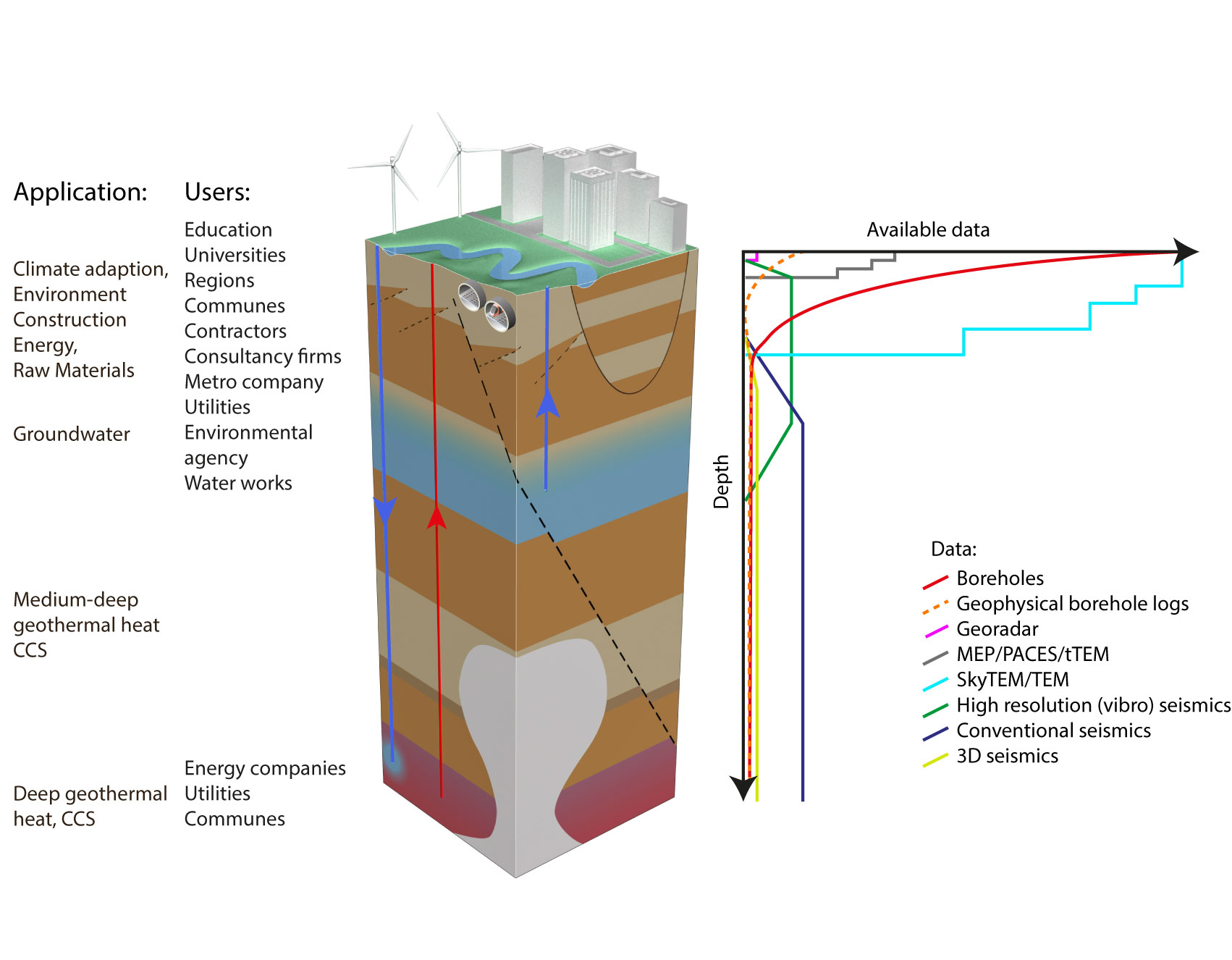
Figure 1: Left: Application and users of a national 3D geological model. Right: Principal sketch of the available data with depth (national scale). There is a significant difference in both the geoinformation usage and the amount of data available at various depths.
Projektleder
Anne-Sophie Høyer